Keyboard ALT + g to toggle grid overlay
What is 3D projection mapping?
3D mapping technology (also called projection mapping or spatial augmented reality) is a technology used to project a 2D or 3D object onto a display surface through spatial mapping. 3D mapping is often used by advertisers and artists to add dimension, movement, and depth to previously static objects such as buildings or stages.
Image courtesy of Andrei Visuals
3D mapping techniques
CAD AND GIS
Spatial data that is digitized or created in GIS can be converted to CAD data and vice versa which can then be manipulated in Autodesk products.

DRONES AND UAVS
Utilize drones and UAVs to survey and create high-quality 3D models that can be mapped to objections for projection.
PHOTOGRAMMETRY
Turn photographs into detailed 3D maps, drawings, and models using photogrammetry for precise measurements.
Featured 3D mapping software


Get Revit + AutoCAD + Civil 3D + more—BIM tools for architecture, engineering, and construction

Professional design software for 2D and 3D CAD

BIM software to plan, design, construct, and manage buildings and infrastructure
Civil engineering design and construction documentation
Model-based mapping software with access to CAD and GIS data

How is 3D mapping software used?

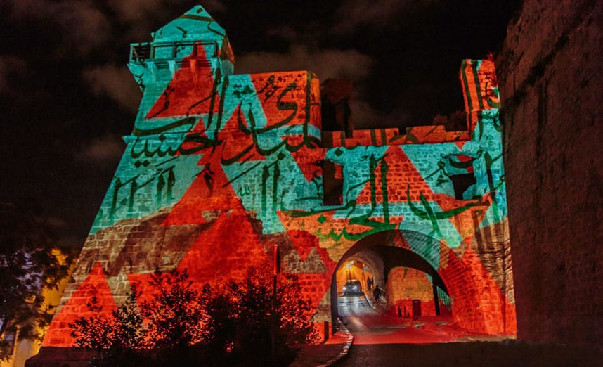
ANDREI VISUALS
AutoCAD projects light in Jordan
Andrei Snobar uses AutoCAD for 3D modeling and mapping to create interactive art installations and animated videos that he projects onto buildings.
See what our customers are doing
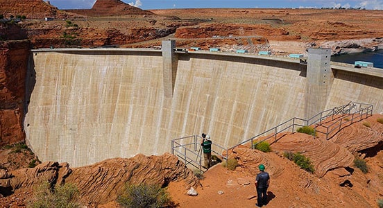
Bureau of Reclamation
3D models help protect critical infrastructure
Reality capture and 3D modeling are helping this US government agency protect the Glen Canyon Dam for generations to come.
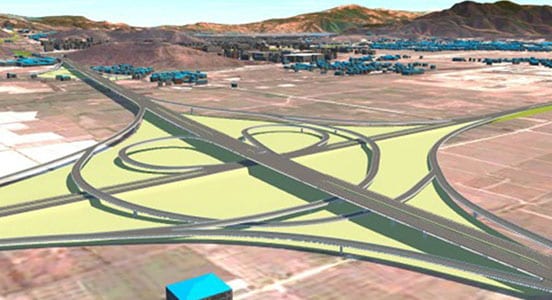
SCODI
Improve road, tunnel and bridge workflows
Chinese engineering firm created visualizations using AutoCAD Civil 3D to communicate its design for a new 69-km highway to government officials.

Autodesk & Esri
A new collaboration between Autodesk and Esri intends to put GIS and BIM at the center of projects, driving smarter decisions, optimized designs, accelerated project approvals, reduced costs, smarter cities, and resilient infrastructure. Building the bridge between GIS and BIM will change the way we plan, design, and build our future
3D mapping resources
Learn more about mapping software with these tutorials, tips, and guides.
-
A series of tutorials that provide an overview of the product and hands-on exercises to help you learn many aspects of AutoCAD Map 3D.
-
This tutorial is for AutoCAD Civil 3D users who need to provide data to, or utilize data from GIS systems.
-
Learn how to locate, use, and configure web-based map services in AutoCAD Map 3D, AutoCAD Civil 3D, and InfraWorks 360 software.
-
Understand the benefits that different reality capture technology can bring to your construction workflows.
-
The use of mobile mapping is becoming increasingly common, from large multi-decade mega projects to rather more mundane state and municipal projects.
-
Learn how drones are being used in construction to more accurately—and safely—capture valuable data from project sites.